The amazing river of Mark Twain and Huck Finn
History
Next to the Missouri, the Mississippi is the longest river in the United States. As settlers started their westward migration, navigating the Mississippi became an integral part of American history. Originally under the control of both the Spanish and French, the river was part of the vast Louisiana Purchase in 1803.
The river was an important aspect of Native American life and culture, and its name is believed to have come from words meaning ?great river? or ?great water.? French fur traders plied the river with keelboats and rafts, which were followed by the advent of steamboats in 1811. The first bridge across the Mississippi was constructed in 1855 in Minneapolis. While much of the traffic ceased during the Civil War, the river was an important invasion route and strategic objective for the Union army.
While railroads captured much of the cargo transport in the late 1800s, there has been a resurgence of freight traffic in the last half-century. Food, grains, chemicals gravel, and petroleum products are all shipped on the Mississippi.
Geography
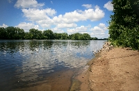
The river originates in many small streams that feed Lake Itasca in northern Minnesota. From there it flows in a generally southern direction, and the middle of the riverbed defines parts of the borders of ten states. Combined with its largest tributary, the Mississippi and Missouri river system is the third longest in the world at over 3,700 miles.
~
The flow of the river is now controlled by 43 dams that contribute to power generation and recreational reservoirs. The flowing river exceeds a mile in width in several locations, and many of the lakes formed by the dams are even wider. The dams south of Minneapolis contain locks to facilitate towboat and barge traffic along the route navigating the Mississippi to New Orleans. In addition, the flow is further moderated by wing dikes that help prevent erosion and preserve the main commercial channel.
The ecology and geography are further shaped by levees that line the river. As a result of years of sediment deposit and buildup of the natural levees, in some areas the surface of the river is above the surrounding river plain. Levee breaches often flood portions of the surrounding low-lying areas.
Navigation
The Mississippi River is navigable all the way from Minneapolis to the Gulf of Mexico. There are man-made canals that circumvent major rapids in Illinois and Iowa to facilitate navigating the Mississippi. During the summer months, the drop in water level requires all vessels to navigate marked channels. From the Gulf to Baton Rouge, the 45-foot channel is adequate for many oceangoing ships. North of Baton Rouge, the 9 to 12-foot channel can accommodate most towboats and barges.
During the winter months, the upper Mississippi is prone to ice, and heavy fog often blankets areas of unfrozen water when the air temperature warms. Most of the dams and falls are in the upper portion of the river since more than half of the 1,475 foot vertical drop occurs in Minnesota.
The Missouri River joins the Mississippi just north of St. Louis, and the Ohio River joins at Cairo, Illinois. South of Cairo, navigating the Mississippi is a calmer experience, as the river meanders through an extensive, low valley that has been built up by sediment over thousands of years. It enters the Gulf of Mexico about 100 miles south of New Orleans through an ever-expanding delta. The river is connected to the Gulf Intracoastal Waterway and to the Illinois Waterway in the north. The latter provides access to the Great Lakes and the St. Lawrence Seaway.
River cities
St. Louis was the gateway for many pioneers that were headed west to start new lives and seek their fortunes. It was no accident that St. Louis and many other cities sprung up along this great waterway. In addition to being a major trade route, it provides a never-ending supply of water for farm irrigation. Other major cities along the Mississippi River include Minneapolis, Saint Paul, Dubuque, Memphis, Vicksburg, Baton Rouge, and New Orleans.
Resources:
42explore2.com: the Mississippi River
InfoPlease.com